Looking at a map, the area around Minocqua is so blue it could be mistaken as a sprawling lake with some intervening islands and land bridges. For a paddler, the options are aplenty whether it’s circumnavigating a flowage, portaging from lake to lake, or paddling down a river. Plus, with so much protected land within the Northern Highland-American Legion State Forest and numerous State Natural Areas, many of the waterways are officially listed as “wild” or “scenic,” meaning development is nonexistent or strictly limited. The options here could keep you busy for years, but here are five great Minocqua Area paddling trips to get you started.
Manitowish River
The Wisconsin Department of Natural Resources offers a free guide to six paddling routes, all within the protected area of the Northern Highland-American Legion State Forest. Four of these suggested trips are on the 44-mile Manitowish River, which runs roughly east to west across the northern reaches of the Minocqua area, from High Lake to the Turtle-Flambeau Flowage. Day trips on river segments with good put-in and takeout spots, start from about three hours, but the river is also great for multi-day travel with waterfront campsites along the route.
Bittersweet Wild Lakes Area
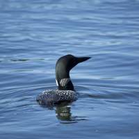
A series of four pristine lakes, this State Natural Area allows no motors and can be accessed by paddlers only by carrying in your craft. For your effort you are rewarded with a fantastically secluded excursion. Portage trails connect the clear lakes and five primitive campsites serve overnighters. The red and white pine and hemlock trees here are some of the oldest in the Northern Highland-American Legion State Forest. Loon sightings are common.
Wisconsin River
The 430-mile Wisconsin River runs through this neck of the woods but this far north is where it just begins to get big. A dam on it creates the Rainbow Flowage, a popular fishing lake. But below that dam is a nice 10-mile stretch of river taking you to the next good takeout. The bottom is rocky and the river flows steady, even kicking up some Class I rapids before slowing and widening a bit after the first three miles. Then the bottom becomes sandy and the river slows a bit. Eagles and osprey are likely.
Tomahawk River
The Tomahawk River winds through pine and hardwood forest, marshy areas, and some high and sandy banks. The 12-mile run from beneath the dam at Willow Flowage just south of Minocqua, is suitable for novices but nevertheless advanced paddlers can consider a 200-foot stretch of Class II rapids to get the adrenaline pumping. If uncertain, this can be portaged around and some lesser Class I rapids and riffles finish out the segment.
Willow Flowage
Looking for some island hopping? Above the dam on the Tomahawk River is the state’s largest undeveloped lake. With 6,400 acres, 117 islands and 33 primitive paddle-up campsites, Willow Flowage is like a shortcut to Canada. The fishing is good and so is the wildlife viewing. Camping is free and first-come, first-served, and six boat landings provide access so you can either return to your parked vehicle or paddle point-to-point across the entire flowage.


